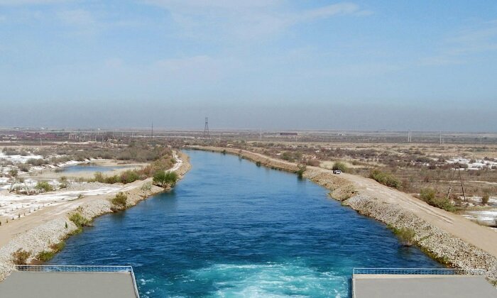
In Turkmenistan, the historically established character of the people plays a special role in water use. At all times, water has been a tangible and intangible treasure in the country, the basis for careful attitude to it, having formed a special culture in water use and water consumption. Doctor of Technical Sciences Allaberdy Ilyasov commented on the construction and significance of the man-made river in the Karakum Desert in an interview with CentralAsia.news.
A vital necessity
At the present stage of social development, water in Turkmenistan plays an environmental role in all technological processes of economic and other activities. Water use is not only a means of production to support life, but also the protection for cities and towns, which stipulates the unity of man and nature. However, water resources on the territory of Turkmenistan are extremely limited.
Therefore, in the early 1950s, the ambitious decision was made to implement a large-scale construction project of the Karakum Canal. Its construction was vital for the development of agricultural sectors. The total amount of water flow barely reaches 3 billion m³ (the lowest figure in the former USSR), which necessitated building this kind of a water management facility to irrigate about 4.5 million hectares of fertile lands, water desert pastures, supply water to cities and industrial centres and settlements, create agricultural bases and public places of recreation nearby, develop fisheries and create a waterway.
Local water resources of the Murghab, Tejen and Atrek Rivers, located in the south of Turkmenistan, are very limited. Based on the average annual flow, the total flow on these rivers is less than 3 billion m³, which can provide 30 m³/ha of plant water per hectare of agricultural land, which is extremely insufficient. Almost 80 percent of the territory of Turkmenistan lacks a constant source of surface water flow. The only high-water river Amudarya, flowing along the eastern outskirts, has two floods: the flood from rains and melting snow from low-mountain areas in spring and the main flood from melting glaciers and snow in high-mountain areas in summer. The construction on the main canal on the territory of Turkmenistan started in 1954.
A choice of a water route
The choice a canal route was very complex and controversial for designers, as they had to address such issues as management of the land fund, minimisation of the work to be done, functional operation of the canal throughout the year and optimal construction site conditions. When choosing a route on the Amudarya-Murgab section, the Southern option of the route was accepted, as it allowed gravity irrigation on 100,000 hectares of land in the Murgab delta and 400,000 hectares of land in the Tejen delta. Kelif Uzboi were used to create lake sedimentation basins and minimize excavation work due to the natural topography by using pits, inter-row and inter-dune depressions under the canal bed, creating natural spills and lakes, which significantly reduced construction cost and accelerated construction works.
When designing a section of the man-made river between Murghab and Tejen at the second construction stage, an option was adopted in which the waterway crossed a section of sandy desert and was conducive to the construction of the Hauzhan water storage reservoir, which regulated the free channel flow and irrigation of large areas of lands. A similar decision was made when designing the third project stage: its route bypassed the Hauzhan reservoir across sections of the sandy desert, ensuring command marks on irrigated lands. On many sections, the route of the man-made Karakum River crosses a sandy desert with permeable soils and deep-lying groundwater in the lithosphere, which necessitated conducting quantitative assessment of the impact of leakage water on the groundwater level.
Given natural conditions, the project provided for a year-round mode of operation of the canal, which allowed for navigation that is a cheap and reliable means of transportation and delivery of goods and inspection of the canal in desert conditions, preservation of fish stocks as an important biological resource and the use of the canal as a source of not only irrigation, but also water supply to cities, industrial enterprises and settlements. In the autumn-winter period, when irrigation systems do not use water from the canal, it is accumulated in hydraulic reservoirs to be consumed in summer. Herbivorous fish — grass carp and silver carp that protect the canal bed from overgrowing with reeds and other aquatic vegetation, which reduces the throughput of channel water flows, is raised.
Stages of large-scale construction
The man-made canal, as a unique technogenic component, was built in several stages. The first stage — from the water intake on the Amudarya River to the Murgab River basin, the technical project of which was approved in 1951, provided for the supply of Amudarya water to Murgab for irrigation of an additional 88,000 hectares in its delta. The first stage of the canal was 397 km in length, of which 300 km ran across the Karakum Desert.
The canal bed is not lined; its flow rate was 130 m³/s, and the annual water intake from the river was 3.5 billion m³. The first construction stage started in 1954, and Amudarya water came to irrigate 33,000 hectares in the Murghab oasis in 1959. 3 cotton-growing state-run farms with a sown area of 30,500 hectares and a fruit and grape growing state-run farm with an area of 2,500 hectares were established on virgin lands. Upon completion of the first construction stage, irrigated land in the Murghab basin covered an area of 170,000 hectares. In 1975, the actual irrigation area was 212,000 hectares.
The second stage — Amudarya-Tejen irrigated 27,000 hectares out of over 700,000 hectares of empty fertile land on average per year, which necessitated building a canal from Murgab to Tejen. It was built in 7 months. It added 72,000 hectares of irrigated land in the Tejen oasis to reach a total of 99,000 hectares, and the canal reached the length of 535 km. After the first stage canal was reconstructed, the channel flow increased to 197 m³/s and, accordingly, the water intake from the Amudarya River increased to 4.7 billion m³.
The third stage — Amudarya-Geok-Tepe supplied water to Ashgabat and its industrial satellite Bezmein and expanded the suburban agricultural base. The innovative 258 km Tejen-Ashgabat canal was built. The flow rate at the head of the canal was 13.7 m³/s in the Tejen River, and 6 m³/s near Ashgabat. 2 water storage reservoirs were built near the capital city: the Western water storage reservoir with a storage capacity of 48 million m³ and the Eastern water storage reservoir with a storage capacity of 6.3 million m³. The third construction stage started in 1966. The project envisaged the irrigation of 50,000 hectares of new land in the Northern Kopetdag Valley and the reconstruction of 20,000 hectares out of 36,000 hectares of existing irrigation land. The annual water intake from the Amudarya River reached 8.3 billion m³. The total length of the canal reached 837 km, and the Ashgabat-Tejen section was 44 km long. A storage capacity of the Hauzhan water storage reservoir increased to 875 million m³.
Future prospects
The fourth stage project — Amudarya-Kazanjik was developed integratedly and envisaged the construction of the canal and water storage reservoirs, land development for irrigation, water supply to cities and industrial enterprises, transport usage of the canal from the Amudarya to Ashgabat, creation of recreational areas and land development for agricultural production, including irrigation on an area of 450,000 hectares. The capacity of the Kopetdag water storage reservoir is to be increased to 550 million m³, water intake from the Amu Darya will be 13.5 billion m³.
The canal runs westwards along the Geok-Tepe-Kizyl-Arvat pioneer canal. In the future, a head reservoir with a capacity of 3.5 billion m³ will be built at the estuary of the Karakum Canal.
The fourth construction stage of the Karakum Canal, with a water flow rate at the head of the canal of 580 m³/s, irrigates 424,000 hectares in all the zones from Murghab to Atrek, of which 90,900 hectares will be new lands.
The construction of the Kopetdag water storage reservoir and the pioneer canal from Geok-Tepe to Kizyl-Arvat at the fourth stage started under separate projects. The water storage reservoir was put into operation in 1975; it is located north of Geok-Tepe and is the end section of the third stage of the canal. The Kopetdag reservoir with a capacity of 219 million m³ regulates the flow in autumn and winter to supply irrigation water via the pioneer canal. The total project area of irrigated land was 240,000 hectares, and together with irrigated area on local runoff in the zone of the canal, 355,000 hectares were to be irrigated. As the throughput capacity grew, the head water intake from the Amudarya River increased to 400 m3/s, which made it possible to expand irrigated land to 514,000 hectares.
Man-made artery
Many years of practice in the operation of the Karakum Canal (80 years) within the spatial limits of the zones of influence have formed an ecological situation that is significantly different from the initial one before construction started in 1954. In the systemic energy-entropy conception (the possibility of integrated control of the energy-ecological characteristics of buildings) on the area of the zones of influence under consideration are determined by the nature and intensity of the indicators. They arise from natural, technogenic and social components, as sources of flows of matter, energy and information.
These sources are determined by systemic integrated environmental monitoring at the stages of design, construction and operation of the «object of activity» in the present example of the Karakum Canal. The practical use of water resources of the Karakum Canal, where the processes of interconnection, interaction and relationship continuously occur between the natural environment together with living organisms inhabiting it in diversity of all forms of interaction with each other and such physical properties as light, temperature, humidity, pressure, soil structure and composition, terrain, including various types of infrastructure facilities, are united by the common name — Karakum Canal, currently called the Karakum River.